


Lake District Hiking: Skiddaw, Little Langdale, and Coniston Old Man
A pictorial guide

Reading time:
short story - novelette - novella - novel - PhD thesis - War and Peace - U.S. Tax Code
Any extracts used in the following article are for non-commercial research and educational purposes only and may be subject to copyright from their respective owners.


Contents
Little Langdale and Cathedral Cave
Introduction
It’s the time of year for Doorless to leave the carp pond and head back to the hills.
Three walks in two days, earlier this week (July ‘25).
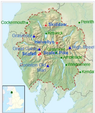
The UK’s Lake District National Park is the UK’s second national park to be founded, a month after the Peak District, on 9th May 1951. It covers an area of 2,362 km2 (912 square miles) and received over 18 million tourists in 2022.
It has four mountains (‘fells’) over 3000’ / 914m, the highest in England being Scafell. Skiddaw is the fourth highest of the group:
Scafell Pike, 978 m (3,209 ft)
Scafell, 965 m (3,166 ft)
Helvellyn, 951 m (3,120 ft)
Coniston Old Man is at the Southern end of the range, whereas Skiddaw is at the North.
I was based at Coniston, as my plans to overnight at Keswick were scuppered by a lack of campsite availability. Thanks must go to the Coniston Sports and Social Centre for their facilities. I paid for my three nights at the bar on arrival. “Would I like to add a pint to the bill?”. It would have been rude not to.
Back to business. Getting parked at Skiddaw meant an early morning 25-mile / 1 hour drive from Coniston. I arrived at 07.30, yet only just managed to get parked in the last available spot.
Skiddaw

Personality: Gracefully monolithic, but with hidden corners. Skiddaw's outline from the south, its most familiar side, is instantly recognisable – a sweeping pile of curving lines drawing inwards, like arms reaching out to embrace the viewer. It's a mountain pleasing to the eye, at once cuddly and pointy.
What's in a name? The origin of the name 'Skiddaw' is up for debate. Medieval versions of the name include Skythou and Skydehow. Most sources now indicate an Old Norse origin, from skúti ('projecting cliff') and haugr ('hill' or 'burial mound').
https://www.ukhillwalking.com/articles/destinations/one_minute_mountain_skiddaw-12877
Start: Latrigg car park, Keswick, CA12 4PH.
What3words: ///corner.pixel.tracks
Grid Reference: NY 28078 25343


Ordnance Survey (OS) Map: The English Lakes, North Western area. OL4. 1:25,000

Distance: 9.0 miles / 14.5 km
Time: 4-6 hours.
Total Ascent: 2667‘ / 813m
GPX Route: “Skiddaw & Glenderaterra Beck from Underscar Walk”
Android App: Locus Map
OpenAndroMaps Downloads for Android: Link
Website with OS Maps (may be deprecated): Link
Garmin OpenTopo Downloads: These are near OS quality and include Basecamp files & DEM contours: Link
Further Reading: How to use OpenStreetMap and OS digital maps


Salehow Beck footbridge:

Skiddaw Forest

Extra-parochial fell pasture, which formed separate CP until absorbed into Underskiddaw CP 1934.
Acreage:
2,969 acres [1,202 ha], almost entirely open fell.
Economy:
demesne cattle pasture in 13th century; fell grazing thereafter. Grouse shooting in 19th century. Hostel for walkers (Skiddaw House) since 1980s
https://www.cumbriacountyhistory.org.uk/township/skiddaw-forest


Little Langdale and Cathedral Cave
A short walk the following morning, whilst waiting for conditions to improve at Coniston. In contrast to Skiddaw, Monday brought low clouds and torrential downpours, but at least the cooler temperatures meant it was much better for walking.
My wide-brimmed sunhat was put to good use again, but this time to stop a torrent of water from running down my neck. Such is the variability of Lake District weather.
Signs put out by the local council tell you where they want you to park for the Cathedral Cave walk: Tilberthwaite.
Start: Tilberthwaite Ghyll car park, Coniston, LA21 8DG.
What3words: ///squish.schematic.vessel
Grid Reference: NY 30622 01016
Ordnance Survey (OS) Maps: You need two OL paper maps as backup. GPS devices are a godsend.
1/ The English Lakes, South Western area. OL6. 1:25,000:
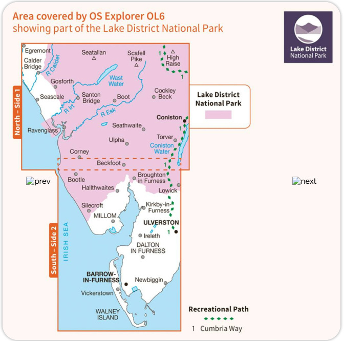
2/ The English Lakes, South-eastern area. OL7. 1:25,000:

Distance: 5.6 miles / 9 km
Time: 2-3 hours.
Total Ascent: 768‘ / 234m
GPX Route: I used this one and followed it anticlockwise, but there are many variants.


Hodge Close is a quarry pit with a depth of over 90 metres (300 feet), half of which is below the current water level.[2] During the quarry's operational use, there were at least three different systems installed for lifting and removing the large slabs of slate (clogs).
A steam crane and a water balanced lift were used to effect in the latter part of the 19th century. During the 20th century, a Blondin crane was used right up until the quarry closed.
… The remains of the water pipe for the water balanced lift, and various support anchors for the Blondin crane are still visible on the periphery; heavy-duty steel, cut and rusted, bygone times of industrial workings, now with an air of peace and tranquillity.


Coniston Old Man
… It is believed that “Old Man” is derived from the ancient Celtic “Alt Maen” meaning “High Stone” and the Coniston part comes from the Old Norse “Konigs Tun” meaning King’s Farm.
https://benthamfootpathgroup.co.uk/the-old-man-of-coniston-from-torver/
I returned to my base in Coniston just after midday and waited to see if the cloud would lift. This took until about 13.30, so rather than do the full 9 mile / 14.5km loop and risk being caught out by nightfall on the Fells, I decided to retrace my steps from the summit.
I always pack a head torch for such an outcome, but as a solo hiker, this would be pushing my luck.
The Tuesday forecast was for torrential rain lasting all day from 06.00, so that wasn’t an option. (In the event, they recorded 40-60mm of rain in just a few hours).
Start: Coniston Sports and Social Centre, Shepherds Bridge Lane, Coniston, LA21 8AL
What3words: ///watching.retained.warblers
Grid Reference: SD 30549 97748
Ordnance Survey (OS) Maps: The English Lakes, South Western area. OL6. 1:25,000:
Distance: 6.0 miles / 9.6 km
Time: 4-6 hours.
Total Ascent: 2470‘ / 753m
GPX Route: Dow Crag & the Old Man of Coniston from Coniston Walk


It is thought that copper and slate mining on Old Man dates back to the 12th and 13th centuries. By the 1500’s slate workings were well established, and the path soon leads you through the remains of the Saddlestone Quarry, at about 1500’ / 457m.
Saddlestone mill
Mandalls Slate Co Ltd worked a number of quarries on the slopes of Coniston Old Man. The main processing area was the mill at Saddlestone to where the slate 'clogs' were brought down by an aerial ropeway and sawn in the shed seen here. There were also a number of riving or dressing sheds on this level. The worked stone could then be sent further down the ropeway towards the Coppermines Valley for outward transport by road.
Remains of the ropeway are still evident right up the hill with both fixed and moving ropes lying on the ground. The collapsed wooden framework was the start of the next flight of the ropeway.
https://www.flickr.com/photos/93173492@N00/5903849227/in/photostream/


Saddlestone Main Bank
Extracted from the Coniston Local History Group website link
"This Bank was the main processing facility and site office for the Old Man Quarries during the last 30 years of operation. However, prior to that, it was a separate underground working which was initially developed in the 1880’s and finally closed just before the 2nd World War.
After closure the entrance to the level leading to the underground chambers became blocked but in recent years has been re-opened (but secured) by local industrial archaeologists. The processing site included an electric saw and riving and dressing sheds. The aerial flight down from Moss Head, high above, terminated at Saddlestone. The road up to Saddlestone was improved to allow motor lorries to reach the site to transport finished product away.
The story has been told of the day the draw rope of the aerial flight snapped as a large lump of slate had just started its journey from Moss Head. As the runaway load passed over the last flight pylon above Saddlestone the block came off the carrier and embedded itself deep in the quarry bank. No one working in the sheds there was hurt or even saw the mishap. The workforce spent several minutes searching for wreckage as they were convinced there had been a plane crash.
Two other aerial flights terminated on the Saddlestone bank. Slate clog from the higher Light Hole workings was brought down to Saddlestone on an aerial flight that passed over Smithy Bank. A separate flight also descended from Saddlestone and terminated, via an intermediate pylon, on the High Brandy Crag bank. Slate clog was brought down to High Brandy Crag to be processed until the road up to Saddlestone was improved."
by Mick Garratt


Google Maps visualisation for context:


Back down to the beautiful Coppermines Valley.
Church Beck waterfall:


One last surprise was when something caught my eye, slithering over a rock along the side of the path.
Two venomous common European adders (Vipera berus) were catching the last rays of the evening sun, at about 6.30.


Parting shots
It was an incredible two days of climbing.
I normally bring British MOD MRE (Meal, Ready-to-Eat) ration packs, but these can be a touch bland, and the hard tack biscuits might be built to withstand nuclear war, but that doesn’t make them very palatable.
Not so with the French military equivalent, which proved to be something of a revelation. Called the “Ration de Combat Individuelle Rechauffable” (Combat Ration Individual Reheatable), or RCIR, there wasn’t anything I couldn’t eat, and if you like French fayre I can recommend giving one a try.


They include a disposable solid fuel burner in the standard 24h pack:

There are rumours they even used to include a small bottle of wine.
Thank you for reading.
Next time normal business resumes, and we return to part II of the review of HPV vaccine pathologies.
Disclaimer
Walking can be dangerous, and all walkers must take personal responsibility for their own safety. You should always carry a backup means of navigation and not rely on a single phone, app or map. This Substack strives to provide accurate information but cannot accept responsibility for changes, errors or omissions.
References
Lake District. In: Wikipedia. ; 2025. Accessed July 19, 2025. https://en.wikipedia.org/w/index.php?title=Lake_District&oldid=1298746106
Dear Doorless, I am always so grateful to receive your emails. No idea how I started following you. I hope one day I get to enjoy one of your walks. Thank you x
This is beautiful. Thank you.